
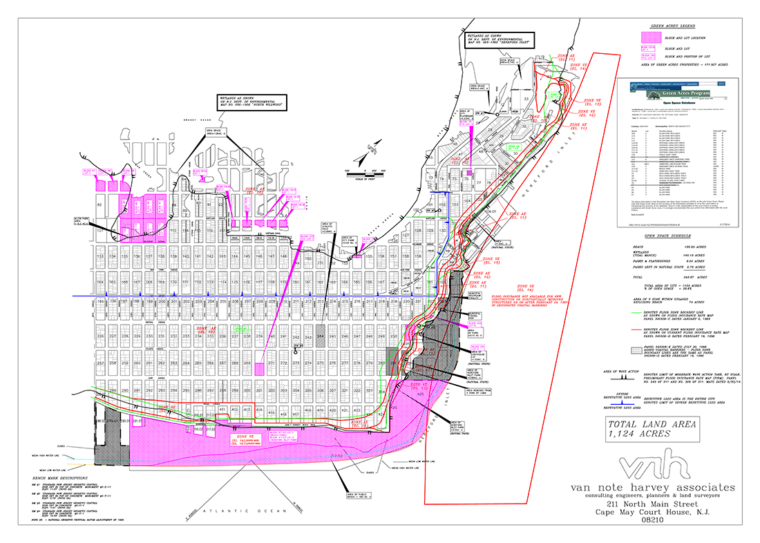
Repetitive Loss Areas, Flood Boundary Zones and Open Space Schedule of the City of North Wildwood

Cape May County Tidal Flood Interactive Map
North Wildwood’s Flood Information Center
Activity 320 – Mapping Information:
The City of North Wildwood and representatives from the Floodplain Management Office: Ronald Simone and Ralph Petrella, City Engineer, provide information regarding flood map inquiries, including but not limited to information on: flood depths, BFE, LIMWA, FIRM, SFHA, V zone, historic flooding, mean high water, sea level rise, projected sea level rise, category 1 hurricane storm surge, projected special flood hazard area in 2050 and marsh migration. For additional information, please contact Joseph Babore at jbabore@northwildwood.com (609) 522-2030 ext. 1340 or Ralph Petrella at (609) 465-2600.
Search My Property: FEMA Flood Insurance Rate Map
Activity 360 – Flood Protection Assistance:
The City of North Wildwood is a participant of the FMA (Flood Mitigation Assistance) program and has submitted an LOI (Letter of Intent) to participate in the program with the Cape May County Office of Emergency Management. Any and all repetitive loss and severe repetitive loss properties with an active flood insurance policy receive notification on an annual basis of the City’s intent to participate in the program, and as of 2016, the City has submitted 15 RL/SRL properties for participation in the program.
Additionally, the City of North Wildwood provides information on flood proofing, grant funding sources for home elevations and flood proofing, ICC (Increase Cost of Compliance) and flood insurance – for additional information including sample policy forms for download, please scroll all the way down to the bottom of this page.
LOCAL FLOOD PROOFING PROGRAM – Army Corp, 2005
Service Provider – Ralph Petrella of Van Note Harvey Associates
PE, City Engineer, CRS Coordinator and Floodplain Manager
Phone: (609) 465-2600 Email: ralphpetrella@vannoteharvey.com
Ralph Petrella is licensed as a PE, PLS and Planner and has been the City Engineer for the City of North Wildwood for +30 years. Ralph has an extensive track record, including several major infrastructure improvements, overseeing numerous parks and municipal building designs and constructions and has worked closely with the building official for the issuance of substantial damage letters after the devastation caused by Super Storm Sandy. Additionally, Ralph has overseen several major dredging/beach replenishment projects, and has served as the Floodplain Manager and CRS Coordinator since day 1 of the City’s enrollment and participation in the CRS program. Mr. Petrella can assist residents with any residential map inquiry relative to the following: flood depths, BFE, LIMWA, FIRM, SFHA, V zone, historic flooding, mean high water, sea level rise, projected sea level rise, category 1 hurricane storm surge, projected special flood hazard area; and also can assist residents with any questions relative to flood protection assistance.
Ralph is intimately familiar with the infrastructure of the city and the damages to property caused by flooding. He has reviewed the Flood Insurance Study for North Wildwood and he is familiar with the methods utilized in producing the Flood Insurance Rate Map. He also has extensive knowledge in cost estimating of structural damage and infrastructure improvements.
As a Civil Engineer he has been in construction procedures and cost estimating for structural repairs and infrastructure improvements. He has also have extensive training in calculating storm water runoff and hydraulics of conduits and stream flow.
To speak with Mr. Petrella regarding flood protection, mapping or construction information, please email or call him via the contact information above.
Links
North Wildwood’s Emergency Preparedness website
North Wildwood Emergency Preparedness Information